send link to app

GPS Tracks app for iPhone and iPad


4.0 ( 7280 ratings )
Travel Navigation Health & Fitness
Developer: David Morneault
Free
Current version: 4.2.9, last update: 6 months ago
First release : 26 May 2011
App size: 61.74 Mb

"One of the better GPS apps for sporting enthusiasts for the iPhone..."
- Bryan Wolfe, AppAdvice.com

Do you want to track your outdoor activities?
Do you need to navigate to waypoints?
Do you want to store your favorite destinations?

GPS Tracks is an ideal app for your outdoor navigational needs, it makes navigating to a specific point and tracking your outdoor activities very simple. It will keep track of your activities and allow you to easliy navigate to coordinates.

GPS Tracks is now available for the Mac in the Mac App Store! GPS Tracks is one of the only tracking applications to sync data between iOS and OS X.

No login or account required, just turn it on and go!

Use Applications -
• Great for hiking offline, running, walking, and biking to track your route!
• Great for photographers who need to track location data for their pictures!
• Great for hunters and fishermen who need to store specific locations!
• Great for military navigational applications!

Features

Live Activities & Widgets
• Live Activity for tracking
• Live Activity for navigating to waypoints
• Lock Screen & Home Screen widget for distance today
• Lock Screen & Home Screen widget for current location
• Home Screen widget for last track and add new waypoint

Track
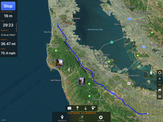
• Track your location/route of your activity
• Store favorite locations
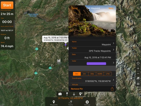
• Take GPS static observations to average current location for more accurate waypoints
• Easily navigate to waypoints with the waypoint guide on the compass
• Add fully editable waypoints on the fly to your current track either manually or from you favorite locations
• Add a vector as a waypoint with angle and distance
• Convert between four sets of coordinates (Decimal, DMS, MGRS, UTM) anytime
• Glide Ratio is viewable and tracked during recording
• Use degrees or mils for the compass
• Add MGRS Grid overlay to map
• Create routes to follow manually before you start your track
• GPS Tracks uses WGS84 datum, over 220 datums available with an In-App purchase.

Measure
• Map measuring tools allow you to measure area and distance on the map
• Draw or drop pins to measure

Apple Watch App
• Track your activity directly with your Apple Watch without your iPhone
• Will save your workouts to the Health app from the watch (only the watch app uses HealthKit)

Connect
• iCloud syncing (will sync between Mac, iPad, and iPhone version)
• Import/Export to Dropbox, iCloud Drive, or iTunes File Sharing
• Send locations to the Navigon/TomTom/Google app or the default Maps app for driving directions
• Share your location with friends with a text message (SMS) or email with a direct link to your location on a map
• Import and export tracks/coordinates in a GPX, KML, BIN, CSV, or NMEA format
• Email exported files
• Export track with photos to KMZ file to export your photos taken during the track

Review History
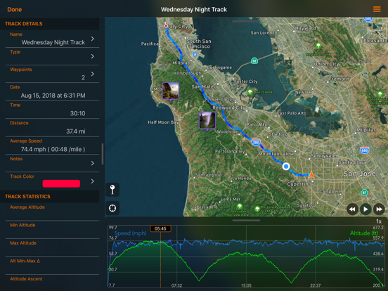
• View your track on the map with the ability to replay the route
• View detailed statistics of the track
• View the waypoints saved with each track
• Change track color

There are many other great features.

GPS Tracks Pro & Premium (Auto-Renewing Yearly Subscription In-App Purchase)
• Use Street, Terrain, Satellite, USGS, NOAA nautical charts, FAA charts, and many other alternate map sources
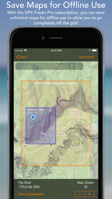
• Save maps for offline use
• Use custom Map Tile Server URLs
• Print Maps in PDF
• GPS Tracks Live - location sharing with friends which allows you to see your friends tracks live on the map
• Weather at waypoints
• Elevation profiles for tracks
• Subscription syncs via iCloud to other devices

Privacy Policy and Terms of Use - http://www.dmsoftwaresolutions.com/privacyPolicyTermsOfUse.html

Continued use of GPS running in the background can dramatically decrease battery life.

Pros and cons of GPS Tracks app for iPhone and iPad

GPS Tracks app good for

Very nice app with broad range of functionality. Very friendly and quick support even to the most detailed questions. Thanks David!
I am tornado chaser and like to track my routes. No better app then this for my needs!!!!
My first review said "Only change I would like to see is having the option to change the speed in history from pace in min/km to mph or kmh" And you listened!! Thank you. Pretty much perfect now!
I use it to track my RC plane by putting my phone with the payload, and it gives me great accurate information. Live the map tracking and speed indicators. Overall great app!
I have tried a number of apps for tracking my hikes and using the GPX file for adding position info to my photos and this is by far the best with outstanding customer service. Set for its most accurate it beat my $500 Garmin and with an incredable number of settings to choose from you can customise it to exactly your requrement
Ive only had this app for a couple of weeks but have found it very easy to use and it has already helped me find my parked car. Great app which Im happy to highly recommend!

Some bad moments

I used to be able to type in coordinates and now when I type them in, it just goes to the nearest city.
Enjoyed using it on a nearly 4000 mile trip. But when I try to export the data it fails....
Love that it works out of the box with no subscriptions. Only pay annually if you want advanced maps such as Topo or flight, the base Apple maps are good enough for cycling. Minus one star for a complicated interface, but with all of its features, no idea how to make it easier. It has also stopped recording while on a ride, and no idea why, but this is rare.
I am very disappointed in this app, especially after paying for it. It is unpredictable and unreliable. Ive used free apps that work a lot better than this one. When I finished my route today it said I did 7 miles. Then changed to under 5.
I am active-duty military and use this app every time I go to the field. On at least two occasions this app has significantly proven its value. If youre looking for an app that has MGRS capabilities on the phone and on the Apple Watch then this app is for you. I even provided some suggestions to the developer and he implemented them in this latest release. Excellent customer service and excellent app for real world field/military use.
I love this app because you can download data in multiple formats like csv which are easily uploaded into many different mapping programs that I use including ArcGIS. It is a little annoying that you can only download in lat/long when there is the ability to view projected data in the app with many different datums (which is very nice). In the end, its not a huge deal because I can project in ArcGIS. If I didnt have access to this software it would be a little more troublesome. It is a great app for referencing my quick field notes when Im working on projects. I used to use a TripMate850, but they dont sell them anymore and this app has more features and options anyway. The only limitation is the phone battery or externals that I bring with me for long days in the field.

Usually GPS Tracks iOS app used & searched for

skitrack, ski tracker, geocache, trail maps, ski tracker app, skitracks, trail tracker gps, offline map, hunting maps, offline maps & navigation, hunting gps, offline topo maps, offline gps navigation, gps location tracker, ski tracks, offline gps, hunting gps maps, hunting land, gps navigation & offline maps, trail tracker, hunting map, offline apps, geocaching gps, gps offline, offline maps, and other. So, download free GPS Tracks .ipa to run this nice iOS application on iPhone and iPad.